
Parts of the Greater Toronto Area (GTA) remain under a snowfall warning while a special weather statement is in effect for Toronto, with up to 15 centimetres of snow expected for eastern areas of the region on Friday.
Natasha Ramsahai, chief meteorologist at CityNews, said on-and-off snow will continue through Friday evening with some heavier bands of snow at times close to midnight, which is when the strongest wind is also expected to come through.
“We’re not quite done with the snow just yet. We’re going to see it more on and off here for the next few hours and may still pick up some additional accumulation. Totals near 10 centimeters for Toronto, less downtown,” she said.
“We should get up to about two or three degrees this afternoon, and that will allow some rainfall to fall along the lakeshore. That’s going to melt up some of the snow that fell over the past few hours.”
Earlier on Friday, Environment and Climate Change Canada issued a yellow-level snowfall warning snowfall for Pickering, Oshawa, southern Durham Region, Vaughan, Richmond Hill, and Markham.
“Snowfall amounts near 15 cm are expected inland from Lake Ontario and over higher elevations such as the Oak Ridges Moraine,” the warning stated. “Lesser amounts are expected near Lake Ontario where warmer temperatures are likely to result in a longer period of rain.”
The national weather agency said snowfall rates of up to five centimetres an hour could fall over some locations.
“The major highways likely to be affected the most with hazardous winter driving conditions are Highways 400, 404, 407 and 115. A return to winter driving conditions is also expected on Highways 401 and 2,” Environment and Climate Change Canada says.
“Travel will likely be challenging. There may be a significant impact on rush hour traffic. Visibility will likely be reduced at times.”
Strong winds are accompanying this weather system with the national weather agency issuing a yellow warning for wind for Burlington and Oakville, extending to Hamilton, St. Catharines, Grimsby and northern Niagara Region. Wind gusts of up to 110 km/h are expected for those areas this afternoon into early evening hours.


For Toronto, winds will briefly peak a few hours after midnight, close to 70 km/h.
In the GTA, temperatures just above the freezing mark will continue through the weekend before another system arrives on Sunday.
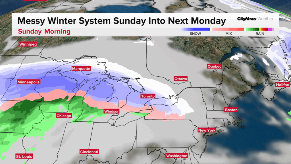
“This is another system that’s likely going to come through with morning snow, switching over to very brief ice pellets and rain, and then we’re going to have a break from the precipitation on Sunday night,” Ramsahai said.
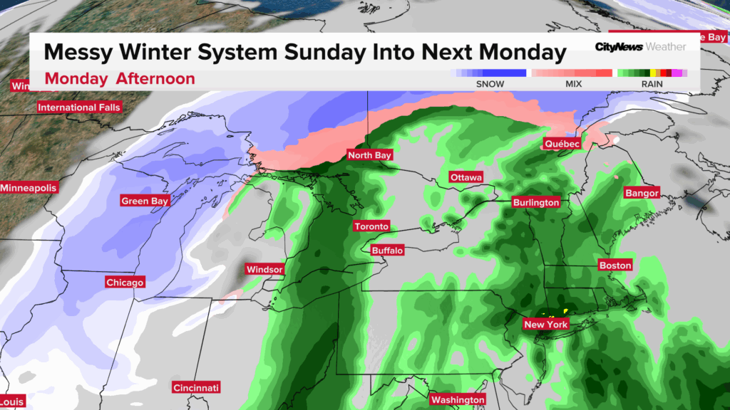
“Early estimates for the Sunday snow, sort of in the two-to-five centimetre range. Less along the lake, higher amounts to the north.” Ramsahai says the track of the Sunday system is still uncertain and forecast snow amounts will be adjusted as we get closer to the event. The same system will bring rain changing to snow on Monday as temperatures fall through the day.
Click here to sign up for the CityNews Weather Guarantee and to check out Toronto’s extended forecast.