The Township of Puslinch is in the midst of planning future development sites, with some new recommendations now being opposed by some residents.
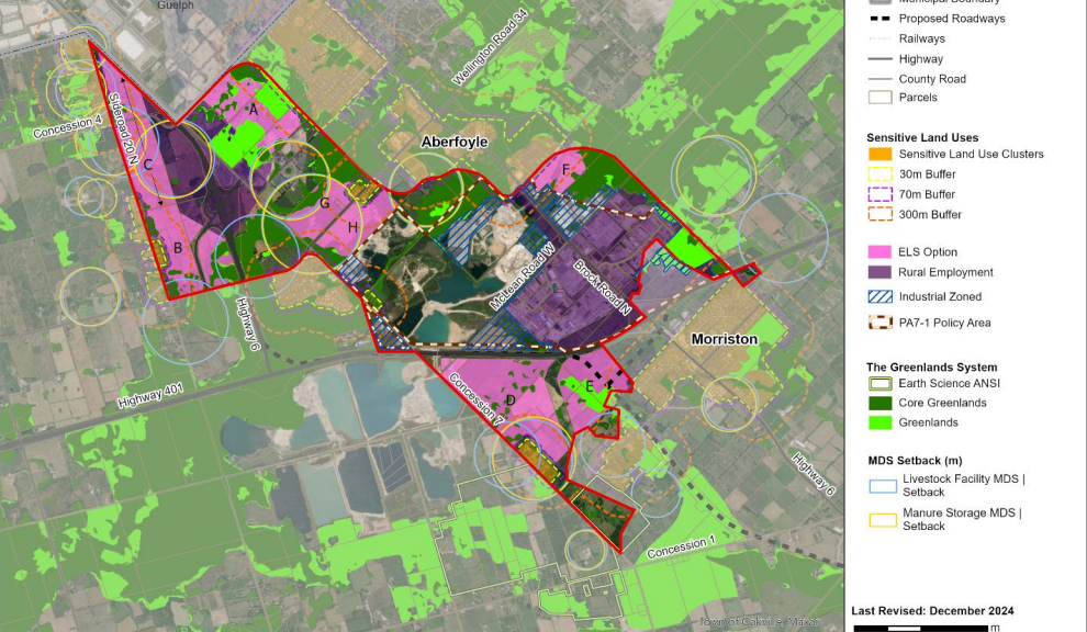
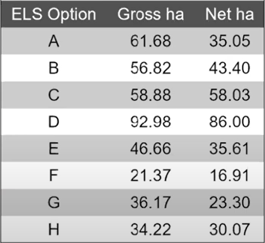
In April, four sites were recommended to Puslinch council for future development, including a large 92-hectare space south of Highway 401 and east of Concession Road for short-term development. The options were labelled as Options A, D, E and F on a map provided by the township’s council.
During a council meeting on Wednesday, four more areas of land were recommended as possible future development sites, including two near the Donkey Sanctuary of Canada. Those lands were labelled as Options B, C, G and H.
David and Sandra Pady of the Donkey Sanctuary spoke during Wednesday’s meeting. Sandra said they are in favour of Option D, as it is near the 401, but Options B and C would have an impact on their business.
“The action clouds the consultant’s recommendations and disregards entirely the opposition to the inclusion of Option B and C in particular by both the DSC and a local group of over 100 concerned residents,” said Sandra.
The sanctuary owns two 100-acre farms, one for the donkeys and another for hay and straw. They bought the one farm just 10 years ago, but have been in Puslinch for over 30 years.
David Pady, speaking on behalf of the group “Help Protect Puslinch” said some of the site would have an impact on local agricultural operations and the township’s “rural identity.”
“Puslinch’s identity is rooting in it’s agricultural landscape, open spaces, and strong farming traditions,” said David.
As part of the county’s official plan, the township needs to put aside at least 30 hectares of land for future development.
Mary Lou Tanner, the president of NPG Planning Solutions, who is making the recommendations, made clear that the lands would need to be confirmed by council before being developed.
“The underlining designation, which is agriculture, is only what is permitted, and that does not change through the proposed official plan amendment,” said Tanner. She notes that it includes Options B, C, G and H.
“In order to move forward for any employment development, a future county official plan amendment would be required.”
No decisions were made at Wednesday’s meeting and a recommendation is coming to council at their meeting on July 23; which will include feedback from the community.