Those scarves and toques were worth their weight in gold throughout Waterloo Region’s wild winter, and after the coldest stretch in over a decade, some double-digit highs are finally on the way.
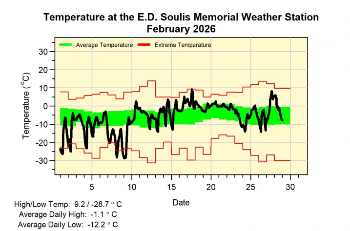
The E.D. Soulis Memorial Weather Station, located at the University of Waterloo, released its findings from December through to February.
It stated that the lengthened cold stretch was the coldest the region has seen since the 2014 to 2015 season, sitting 2 C below the usual average, adding that the cold weather was met equally with snowfall.
“The total so far this snowfall season of 226.0 cm is now tied for first place for the end of February,” the station said. “But unless we get a lot more in March, it will likely not be the snowiest season we have seen in the region.”
It said the cold first half of February, with a day that hit as low as -28.7 C on Feb. 9, marked the coldest temperature the region has seen in four years.
While the numbers point to what’s been a brutal winter, the forecast is finally bringing a bit of positivity as spring inches closer.
“Big temperature swings are coming. Highs of 16 C, down to a low of 0 C Saturday night,” said 570’s Weather Specialist Denise Andreacchi. “We’re warming up for Sunday afternoon, sunny and near 11 C. Monday is probably one of the best days we’ve had in ages.”
She added that it will start with a bit of wild weather, kicking off with “windy and unsettled Saturday, but temperatures are expected to climb to near 16 C tomorrow.”
While the region battled through that record-cold winter, the upcoming warm-up is not expected to go quite as similarly extreme in the opposite direction.
“This warm stretch, that lasts from about March 6 until March 12, it’s not record-breaking,” said Meteorologist Trudy Kidd with Environment Canada. “The record for Saturday, for example, is 18.5 C, so we’re a little bit off that.
Kidd stated that the double-digit warm stretch that’s headed for Waterloo Region is due to a jet stream that will push a blast of heightened temperatures.
“The jet stream is like a highway of fast-moving air high above us, and it’s steering mild air our way instead of the cold Arctic air that we were basically getting used to,” she said. “That’s why temperatures will be spring-like for several days.”
While the warm-up is set to bring a reprieve, it’s also expected to go hand-in-hand with plenty of rain.
Environment Canada issued a rainfall warning Friday, saying rainfall amounts of up to 40 mm could fall by Saturday evening.
“Several rounds of showers and isolated thunderstorms are expected with the first expected to move into Ontario this evening,” the weather authority said. “The rain combined with mild temperatures will likely melt much of the significant snowpack and lead to additional runoff.”
Ponding on local roadways is expected and drivers are encouraged to proceed with caution.
The rain, alongside the upcoming double-digit warm-up, has already led the Grand River Conservation Authority to issue a flood watch for the local watershed.

“The snowpack across the watershed is expected to melt due to the forecasted warm temperatures, and when combined with the predicted rainfall, will result in rising water levels,” said the GRCA in a statement. “Many river systems are still covered with ice, which is expected to melt and, combined with runoff from this event, will increase the potential risk of ice jams and flooding in areas typically prone to flooding.”
It recommends keeping a distance away from rivers and streams throughout the region, encouraging the public to “exercise extreme caution around all local waterways,” particularly for children and pets, as well as to “stay off any ice-covered waterbodies, due to unsafe conditions.”
Looking ahead to what residents can expect through the rest of March, Kidd said, “Fingers crossed that it’s not going to go way back to well below normal temperatures, but I am seeing a swing in the other direction.”
According to that longer-term forecast, temperatures are expected to dip back down before next weekend, sitting closer to the freezing mark by Thursday, March 12.